Here's how to start...
There are a number of ways that students can complete a Trent CBR research project. You either need to be enrolled in a Trent University or Fleming course that offers CBR. Current courses at Trent include but are not limited to: ERST 3080Y, ERST 3130H, ERSC 1010Y, ERSC 3160H, ERSC 3840H, ERST 4250H, BIOL 3890, FRSC 4890Y, GEOG 3820H, GEOG 4830Y, IDST 4220Y, and SUST 5901H.
There are a number of ways that students can complete a Trent CBR research project. You either need to be enrolled in a Trent University or Fleming course that offers CBR. Current courses at Trent include but are not limited to: ERST 3080Y, ERST 3130H, ERSC 1010Y, ERSC 3160H, ERSC 3840H, ERST 4250H, BIOL 3890, FRSC 4890Y, GEOG 3820H, GEOG 4830Y, IDST 4220Y, and SUST 5901H.
OR…
You can apply to do an independent project under the supervision of a faculty member. Most of our independent projects commence at the beginning of each semester, but opportunities may be available at any time throughout the year. Click here for an link to our "Student Application Survey"
OR…
You can complete a CBR project as your master’s thesis. A number of community-based projects are broad in scope, require a high level of academic skill and more time for completion. Review the project descriptions for proposals that suggest group work or graduate level work. If a project interests you, contact us directly to discuss. CBR is a unique opportunity to apply your research skills while also gaining valuable professional experience!
* Click on the title of available projects for more details regarding the project proposal!
Available 2024 - 2025 U-Links Projects (Haliburton County)
Below is a list of available projects in Haliburton County. If you are a student researcher and see a project that you are interested in or would like to learn more about them, you can also check out project here, email Daniela Pagliaro, Administration and Logistics Coordinator ([email protected]) or submit an application form (link below).
Benthic Macroinvertebrate Biomonitoring Projects
(Multiple Projects Available - CLICK HERE FOR FULL LIST!)
NOTE: These projects may involve a field component (semester dependent).
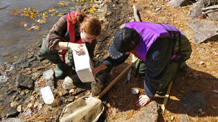
Benthic macro-invertebrates (or “benthics” or “benthos”) are aquatic, spineless organisms that live on the bottom of water bodies. Since the late 1980’s they have been used as biological indicators for common aquatic pollutants as they spend part or the entirety of their lives in the water. The use of benthics as an indicator of water quality is now used throughout the world and has been widely used in Ontario since the early 2000’s.
These community-based research projects are ideal for an undergraduate student as a full-term project and will include field work early in the fall. These projects can also be completed in the winter semester, which includes a lab component but no field work. Students are recommended to have OBBN certification or other previous field work experience. These projects are designed to be full year projects, starting in September and ending in April.
(Multiple Projects Available - CLICK HERE FOR FULL LIST!)
NOTE: These projects may involve a field component (semester dependent).
Benthic macro-invertebrates (or “benthics” or “benthos”) are aquatic, spineless organisms that live on the bottom of water bodies. Since the late 1980’s they have been used as biological indicators for common aquatic pollutants as they spend part or the entirety of their lives in the water. The use of benthics as an indicator of water quality is now used throughout the world and has been widely used in Ontario since the early 2000’s.
These community-based research projects are ideal for an undergraduate student as a full-term project and will include field work early in the fall. These projects can also be completed in the winter semester, which includes a lab component but no field work. Students are recommended to have OBBN certification or other previous field work experience. These projects are designed to be full year projects, starting in September and ending in April.

#5029 Delineating the Velocity of Climate Change in the Haliburton Highlands for the Haliburton Highlands Land Trust
NOTE: This project can be completed remotely.
The Haliburton Highlands Land Trust has as its mandate “to conserve plants, wildlife and clean water of Haliburton County to ensure a legacy of forests, fields and wetlands, and the species they nurture.” To achieve this goal the HHLT is acquiring lands of ecological and cultural significance for conservation purposes. Informed and science-based decision-making is necessary to acquire and manage these landscapes in perpetuity as is the main responsibility of HHLT. Analytical landscape evaluation processes and tools are seen to be key to HHLT decision-making for new acquisitions, land management, monitoring and stewardship endeavours.
This project has as one its purposes to critically review one method available for estimating the velocity of climate change in the Haliburton Highlands region. A second purpose is to recommend how this method can be applied by the HHLT for achieving its mandate of landscape conservation. This project is designed to for a single semester.
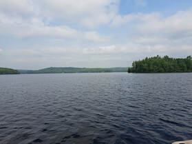
#5115 Lakeshore Capacity Study of Gull Lake
NOTE: This project may involve a field component
The Lakeshore Capacity Assessment Handbook (LCAH), prepared by the Ministry of the Environment in partnership with the Ministries of Natural Resources and Municipal Affairs and Housing, was developed to provide guidance to municipalities and other stakeholders responsible for the management of development along the shorelines of Ontario's inland lakes within the Precambrian Shield. A Lakeshore Capacity Assessment can be used to predict the level of development that can be sustained along the shoreline of an inland lake on the Precambrian Shield without exhibiting any adverse effects related to high phosphorus levels.
The last time a Lakeshore Capacity Study was completed for Gull Lake was nearly 10 years ago. Since then, cottagers have increased their time spent at the lake and short-term rentals have continued to escalate (specifically in timeline since global COVID-19 pandemic). Gull Lake has populations of lake trout which is one of the circumstances used to trigger a Lakeshore Capacity Study. The purpose of this study is to determine the Lakeshore Capacity of Gull Lake by incorporating changes in development and nutrient inputs since the last assessment. This project is designed to span one semester, from September to December.
#6155 Creation of an Informative GIS Map for Drag and Spruce Lakes Property Owner's Association (DSLPOA)
NOTE: This project can be completed remotely.
The purpose of this project is to create an informative GIS map for the Drag and Spruce Lakes Property Owner's Association (DSLPOA). The map aims to provide DSLPOA members with an easily accessible, comprehensive tool for understanding and navigating their lakes and the surrounding amenities. The project equips DSLPOA with a powerful tool, enhancing their ability to communicate essential information to their members. Additionally, the project will foster environmental awareness and facilitate recreational planning that contributes positively to the management and protection efforts of DSLPOA to their lakes and ecosystems. The project will contribute to the broader environmental awareness and stewardship in the county, as DSLPOA members engage with ecological features on the map and take actions to project their local environment. This project is designed to span one single semester.

#6171 Lead Weight Exchange Program Feasibility Study
NOTE: This project can be completed remotely.
The purpose of the feasibility study project is to explore the implementation options of an exchange program addressing hazardous materials to loons, specifically lead fishing equipment, in Haliburton County. It will aim to assess the economic feasibility, engage stakeholders, understand market dynamics and develop effective strategies for promoting the transition to non-lead alternatives. It offers benefits to local community by engaging community members and local businesses in the development and support of exchange programs. This project may lead to cost savings for both business owners and anglers while fostering awareness and action for environmental conservation.
|
#6161 Harvest Haven: Unveiling Haliburton's Bounty Through Agri-Tourism
NOTE: This project can be completed remotely. This project is hosted by ATIP Haliburton, an organization that was formed to collect information on Haliburton County apple orchards, including old and new varieties and locations.The purpose of this project is to help market and promote existing agri-tourism experiences and industry not limited to apple production in Haliburton County, and to create a year-round schedule of all events, experiences and attractions. Types of activities to include on this calendar would be Agriculture Fairs, the Garlic Festival, Maple Syrup Festivals, Farm Gate Tours, the Apple Blossom Tour, and many more. The end goal of this project is to create a marketable timeline of all the agri-tourism events in the county to encourage repeat visits, to help educate visitors and locals about food production, and to highlight the importance of the agricultural industry in Haliburton County. This project can be completed in a single semester or as a full-year project at the discretion of the matched students. |

|
#6163 Waste to Wisdom: Global Insights for Sustainable Incineration Practices
NOTE: This project can be completed remotely.
This project is hosted by Environment Haliburton (EH) an organization which aims to take a comprehensive view of environmental issues in Haliburton County to provide a strong voice to encourage positive initiatives and oppose those that could have an adverse effect on the environment. The purpose of this project is to determine if incineration would be an appropriate choice for dealing with waste in Haliburton's small, rural and remote location with multiple water bodies. This will be done through a comprehensive literature review, the gathering of technical data from existing incineration plants, and the identification of mitigation measures related to waste management and environmental health. This project is designed for a single student, and would span a single semester.

#5081 Serenity Wetland Assessment (Available for SPRING and SUMMER Semesters!)
NOTE: This project involves a field component.
Many of the wetlands in Haliburton County remain unclassified, with their provincial significance unknown. The Serenity Wetland Alliance (SWA), is a volunteer group dedicated to the protection of the Serenity Wetland in Highlands East, ON. The purpose of this project is to gather relevant data and complete an inventory of species present through research and fieldwork, to initiate an Environmental Impact Assessment. The results of this project will promote the awareness of wetlands and their importance, and support other groups and organizations who are considering seeking protections for wetlands in their communities. This project is designed to be conducted in the spring and summer semesters, from May-August.
*This project is best suited for a small group at the graduate level.

#5094 Underground Greenhouse Feasibility Study
NOTE: This project can be completed remotely.
The purpose of this project is to research the feasibility of building an underground greenhouse/walipini for growing food in Haliburton County 12 months a year. How can sustainable features such as fishpond irrigation, geothermal and ceramic wood heat be integrated into the design? What innovative, local, or green engineering and construction features can be used? This project would aid in sustainability and self sufficiency for growing food in Haliburton County and provide an ongoing educational component to the area. This project is designed to span one full school term, from September to April.

#6172 Loon Artificial Nesting Platform Project
NOTE: This project involves a field component
The purpose of this two-semester research project in Haliburton County is to investigate, optimize, and promote the sustainable coexistence of loons and the local ecosystem. Through an integrated approach, the study aims to understand the ecological factors influencing loon nesting, refine artificial nesting platformdesigns, and actively engage the local community. This project seeks to enhance the conservation of loon populations while addressing factors such as predator dynamics, climate change resilience, water quality, human impacts, genetic diversity, and food availability that may affect their well-being in the unique and dynamic environment of Haliburton County. The project will align with EMAN protocols to ensure rigorous and standardized data collection, analysis, and reporting.
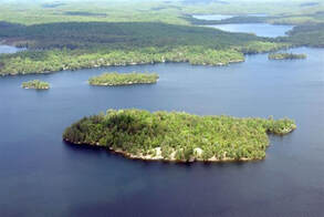
#6059 Seed Bank Feasibility Study of Norah's Island
NOTE: This project involves a field component
Norah’s Island is a 22-acre pristine island on Kennisis Lake. The seclusion, and limited access to visitors, makes the island an area where the old growth trees have not been ravaged by current diseases or disturbed by humans. The purpose of this study is to preserve the local flora for generations to come. Specifically, by completing a seed bank a feasible study for Norah’s Island. Students will visit the island to begin the seed collection process and inventory analysis for current plant and tree species. This project is designed to span one school year from April to September.
|
#6162 Community Kitchen's Project
NOTE: This project can be completed remotely. The ATIP Haliburton organization was formed to collect information on Haliburton County apple orchards, including old and new varieties and locations. The purpose of this study is the identify organizational, coordination, education, and promotion strategies and structures to increase interest in, and feasibility of, using existing commercial kitchens for procession and preservation of local apple harvests.The student will also identify and list the commercial kitchens that are present in Haliburton County, and canvas those locations as well as apple tree growers to determine interest in this type of social event. Students will also determine which types of products would be most suitable for local apple growers to create through this event, such as pies, pastries and other apple-based products, as well as determining what business's in the county may be interested in selling these locally produced apple products. This project can be completed remotely, and is designed to span a full school term (2 semesters), and is most suitable for a single undergraduate student. |

|

#6252 Carbon Stock Assessment Strategy for the Haliburton Highlands Land Trust
The Land Trust seeks to implement conservation management practices that build climate change resilience, protect lands and waters and maintains biodiversity. One area of conservation management that is becoming more prevalent is carbon assessment of lands, and particularly those lands that require nature-based conservation solutions for protection. Ontario Nature lists the following benefits of assessing carbon stocks: improving land management, increasing protection, achieving sustainable forestry certification, enhancing public education, informing future research priorities, and potentially attracting financial support for conservation. With this project, the HHLT wishes to explore methods
for assessing carbon sequestration in the Haliburton Highlands such as the Highlands Corridor and the Land Trust’s properties and to make strides towards deciding on a strategy for estimating carbon sequestration and completing a preliminary carbon assessment.

#6129 Ecologically Aware Gardening Project
NOTE: This project has a field component.
Founded in 2020 at Haliburton Village's historic Lucas House, the Corner Gallery showcases works by Ontario artists, with a focus on abstraction and modern Canadian landscapes. The Corner Gallery provides a space for works demonstrating tradiational methods and skills that help us to see the world around us in innovative and provocative ways. The Corner Gallery is hosting this project regarding the creation of ecologically aware gardens, and would like to use this project to determine the benefits of these types of gardens over traditional lawns.
The purpose of this project is to identify ecological impacts of converting traditional lawns/gardens to an ecologically aware garden that features exclusively native plants. The project will compare and contrast these two garden types on variables like macro-invertebrate and soil microbial diversity, plant-pollinator dynamics and hydro-logical processes. The results of this project will be used to benefit the organization by providing information that can lead to furthering environmental awareness, cost savings, community engagement and enhanced biodiversity, and will be used to benefit Haliburton County by identifying the benefits of ecologically aware gardens. Results of this project will be used to inform the general public about the benefits and identified frameworks for establishing an ecologically aware garden in replacement of traditional lawn management practices. This project is designed to be a full year project from September to April.
#6141 Light Pollution Study on Paudash Lake
NOTE: This project has a field component.
The purpose of this project is to assess how light pollution affects the biodiversity, aquatic life and behavior of wildlife, while also assessing the perceptions and attitudes of local cottagers and nearby residents towards outdoor lighting on and around Paudash Lake. The results of this project will promote the following themes within the Paudash Lake community: ecosystem conservation, dark sky preservation, community engagement, policy recommendations, education and outreach, and enhancing the overall quality of life of residents. This project will benefit the County of Haliburton by promoting environmental stewardship, community engagement, increasing public awareness and eduction, and further policy development that can be replicated in other areas of the county addressing similar issues. This project is hosted by the Paudash Lake Conservation Association, which serves as an advocacy organization to protect the interestes of those living on and near Paudash Lake.

#6142 Paudash Lake Conservation Association Lake Health Survey
NOTE: This project has a field component.
The purpose of this project is to evaluate the knowledge and awareness of Paudash Lake residents regarding their role in lake health contributions, as well as to identify areas where additional education would benefit the cottagers and lake association overall in conservation efforts. By providing results tailored to the organization, this project will help to outline key issues or concerns on Paudash Lake, and can be used to suggest the best management strategies to help mitigate any potential issues that may be uncovered as a result. The project also aims to help the organization in strengthening their advocacy efforts for policies and practices that support lake health, and by promoting environmental stewardship, community engagement, increasing public awareness and education, and furthering policy development that can be replicated in other areas of the county facing similar issues. This project is hosted by the Paudash Lake Conservation Association, which serves as an advocacy organization to protect the interestes of those living on and near Paudash Lake.

#6254 Assessment of Remote Sensing and Imagery Data for the Haliburton Highlands Land Trust
The purpose of this project is to determine the potential for use of remote sensing and GIS imagery to help the HHLT better achieve its land conservation and ecological management mandate. Remote sensing and GIS imagery are seen to provide a broader view of the Haliburton Highlands in the context of its landscape classification, biodiversity, biological connectivity, and ecological changes over time.
The HHLT is currently working towards the development and implementation of strategies and approaches that would ensure it can meet its management, monitoring, and land stewardship responsibilities in perpetuity. Having resources and tools, such as what remote sensing and imagery technologies offer, will allow the Land Trust to better monitor and plan for landscape, biodiversity, and climate change.

#6255 Critical Tributaries Restoration
Harcourt Park is positioned at the height of land on the Algonquin Dome. As such, there are many small tributaries that form a network that drains to the Irondale/Gull River watershed in the west, and to the Elephant Lake/Madawaska watershed in the east. These tributaries are small but in combination they transport significant volumes of water, much of it cold groundwater. Based on multi-year research led by Fleming Professor Charles Rumsey, it was determined that one of these small tributaries was important to rearing of Brook Trout in East Lake. Further, two of the tributaries appear to sustain coldwater upwellings where the Trout Spawn. Four of the tributaries are crossed by the road network and only just recently has the impact of road maintenance on fish habitat been considered. A consultant was hired to prepare mapping of these tributaries to assist with siting of a communications tower. This is a small example of how useful this mapping would be in terms of public awareness and as input to frameworks for road and driveway management. The purpose of the project is to advance our understanding of the density of the tributary network inn Harcourt Park
and to develop a tool to assist in identifying appropriate mitigation plans for road and driveway maintenance. At the moment members think nothing of filling in wetlands and tributaries to meet their needs (access, parking).
Matched Projects for the 2024-2025 Academic Year
Congratulations to the student researchers who have matched up with the following local research projects!
To be announced...
Completed 2023 - 2024 Projects:
#5030 Watershed Mapping Profile and Protocol for the Haliburton Highlands Land Trust
#5057 Windy Pine Shoreline Rehabilitation Action Plan
#5064 Virtual Adaptation of Abbey Gardens on-site Sprouts to Snacks Program
#5080 Grace Lake Wetland Assessment
#5110 Haliburton County Agriculture & Food Production Assessment
#6117 Heritage Apple Project - Apple Tree Economic Cost Benefit Analysis (ATECBA)
#6018 Evaluation of Water Quality Testing Data of Haliburton County Lake Associations
#6119 Winter Water Quality Conditions in the Kawartha Lakes
#6020 Microplastics Analysis of Haliburton County Lakes
#6032 An Overview of North American Partners in Conservation Programs
#6049 Watershed Management Protocols and Practices
#6069 Plant Monitoring at a Tall Grass Prairie Restoration Site
#6089 Heritage Apple Project - Apple Tree Identification
#6127 Portage Route Traditional Rights of Way Initiative
#6128 Kennisis Lake Aquatic Invasive Species Survey
#6131 Aging Together as a Community Project
#5028 Assessment of Remote Sensing and Imagery Data and Tools for use By the Haliburton Highlands Land Trust
#6058 Ground Beetle Monitoring at a Tall Grass Prairie Restoration Site - PHASE II
#6115 Heritage Apple Project - Apple Preparation, Processing and Preservation Practices of the Past (APPPPP)
Children's Water Festival Activity Leads
Haliburton County Biomonitoring
Completed 2022 - 2023 Projects:
#5121 Ground Beetle Monitoring on a Tall Grass Prairie Restoration Site
#5111 Abbey Retreat Centre Programming Evaluation Assessment
#5020 Health Benefits of Natural Plasters
#5108 Botanical and Entomological Study of the Minden Riverwalk
#5087 Exploring Eurasian Watermilfoil and the Impact on Lake Water Quality - Phase II
#6033 Monitoring Protocol for the HHLT Property: The Berry Wetland Reserve
#5088 Best Practices for Lake Monitoring and Management
#6019 Loon Habitat and Mortality Study
#5101 Halls and Hawk Lakes Benthic Assessment
#6021 Permanent Sample Plots for Barnum Creek Nature Reserve
#5040 Glamor Lake Benthic Assessment
#5098 Upper Stoney Lake Benthic Assessment
#5107 Beetle Taxa in Forest Regions
#5126 Blowflies Taxa in Forest Regions
#5089 Koshlong Lake Benthic Assessment
#5096 Gull Lake Benthic Assessment
#5095 Twelve Mile and Little Boshkung Lakes Benthic Assessment
#5099 Bob Lake Benthic Assessment
#6051 Grace Lake Benthic Assessment
#6052 Blue Skies Festival Bioblitz Plan
Children's Water Festival Activity Leads
Haliburton County Biomonitoring
To check out other available projects hosted by the Trent Community Research Center, check out their available projects page here.